The Stemmons Freeway Sign Exact Location in Dealey Plaza
Research: Source Data
This is a quick study on the Stemmons Freeway Sign, as depicted by the Zapruder film and later photos. The source for this location consists of the following:
- I assume that Zapruder was standing on the “Zapruder Pedestal,” as identified in the literature. This position has been debated, but is widely recognized as accurate.
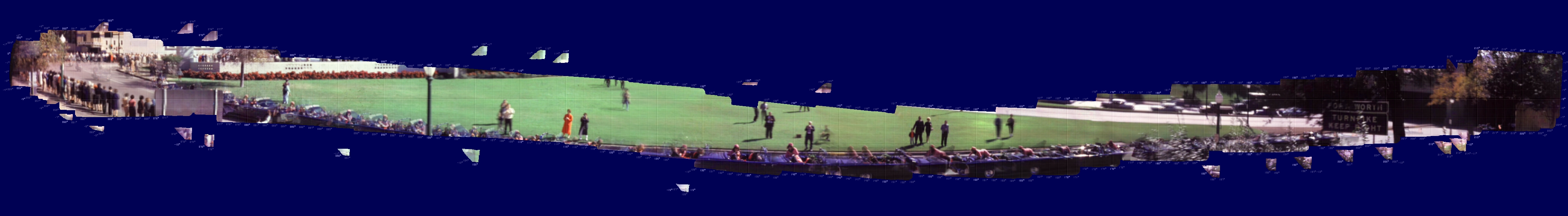
- John Costella’s survey, direction, and compass bearing work that uses the Zapruder Film and subsequent panoramas of Dealey Plaza. I use his panorama of the stictched/combined Zapruder Film, along with bearing lines from True North. (Figure 1)
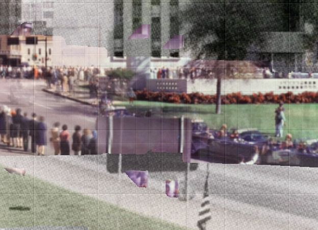
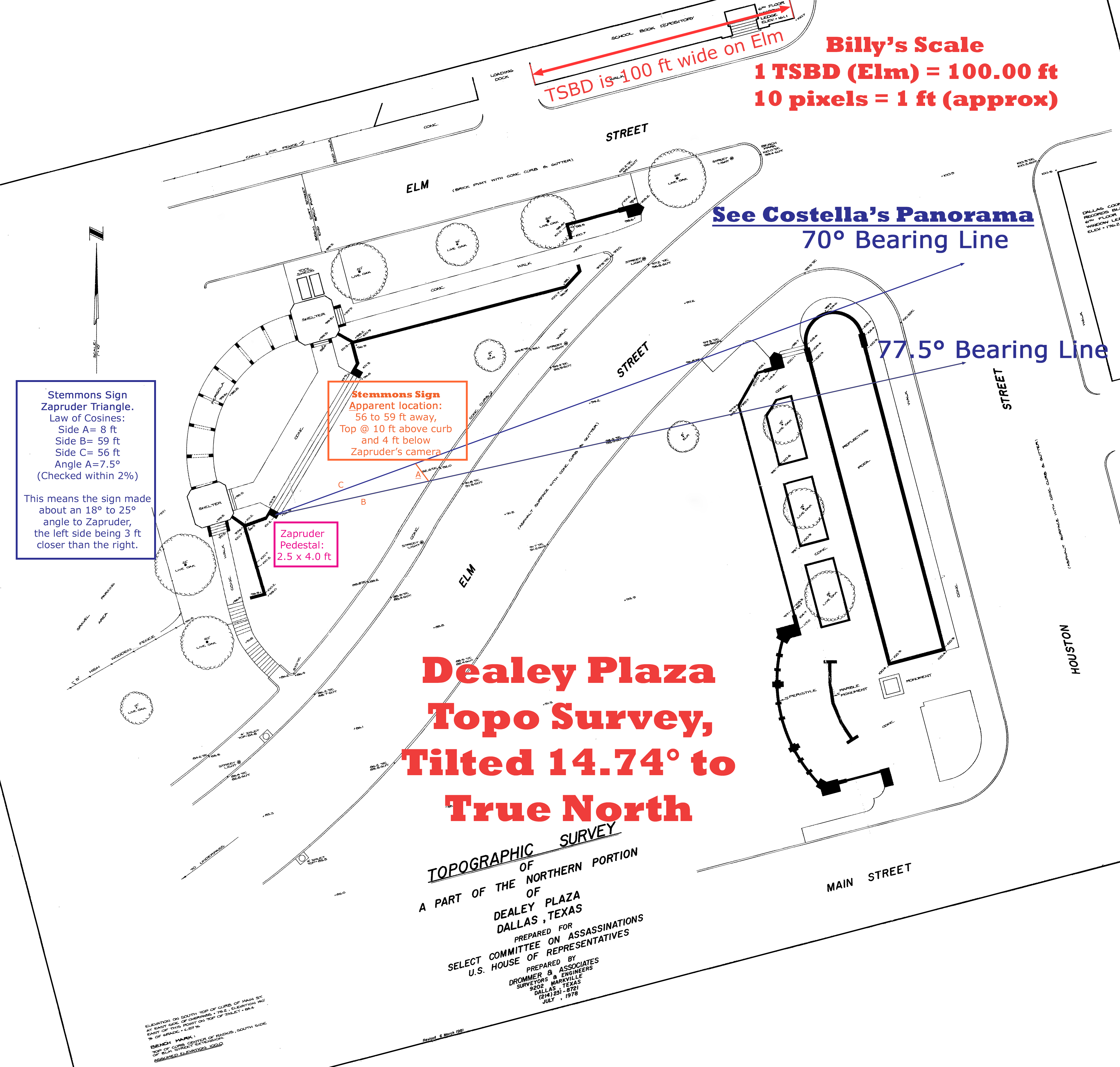
Figure 1: Cropped Panorama showing Stemmons Sign. The bearing lines show a sign that is about 7.5° wide. See more of his panoramas of Zapruder in Dealey Plaza. - The Topographic Survey of a Part of the Northern Portion of Dealey Plaza, Dallas, Texas, Prepared for the Select Committee on Assassinations, U.S. House of Representatives prepared by Drommer & Assosciates in July 1978, Revised 6 March 1981. This survey includes a “benchmark” of 100.0 ft at a spot on the Elm Street curb. Zapruder’s Pedestal is listed at 101.2 ft, and the top of the sidewalk curb (T/C) near the sign is 92.6 ft. (Figure 2)
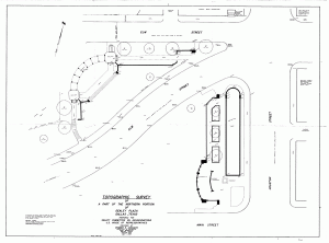
Figure 2: The raw topographical survey of Dealey Plaza, before cleaning it up and rotating it. - I assume, based on a search of source data, that the Elm Street dimension of the Texas School Book Depository is 100.0 ft. (Incidentally, it is 97.0 ft. on Houston Street.)
- I found a few photos of the front of the Stemmons sign. One photo was taken with the “Cuban/Dark-Complected man” sitting very close to the sign. This will help know where the sign was installed in relation to the sidewalk curb and its approximate height. I make the assumption that the sign is about 1 ft. from the curb. (Figure 3)
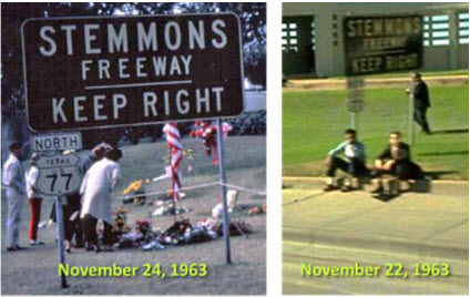
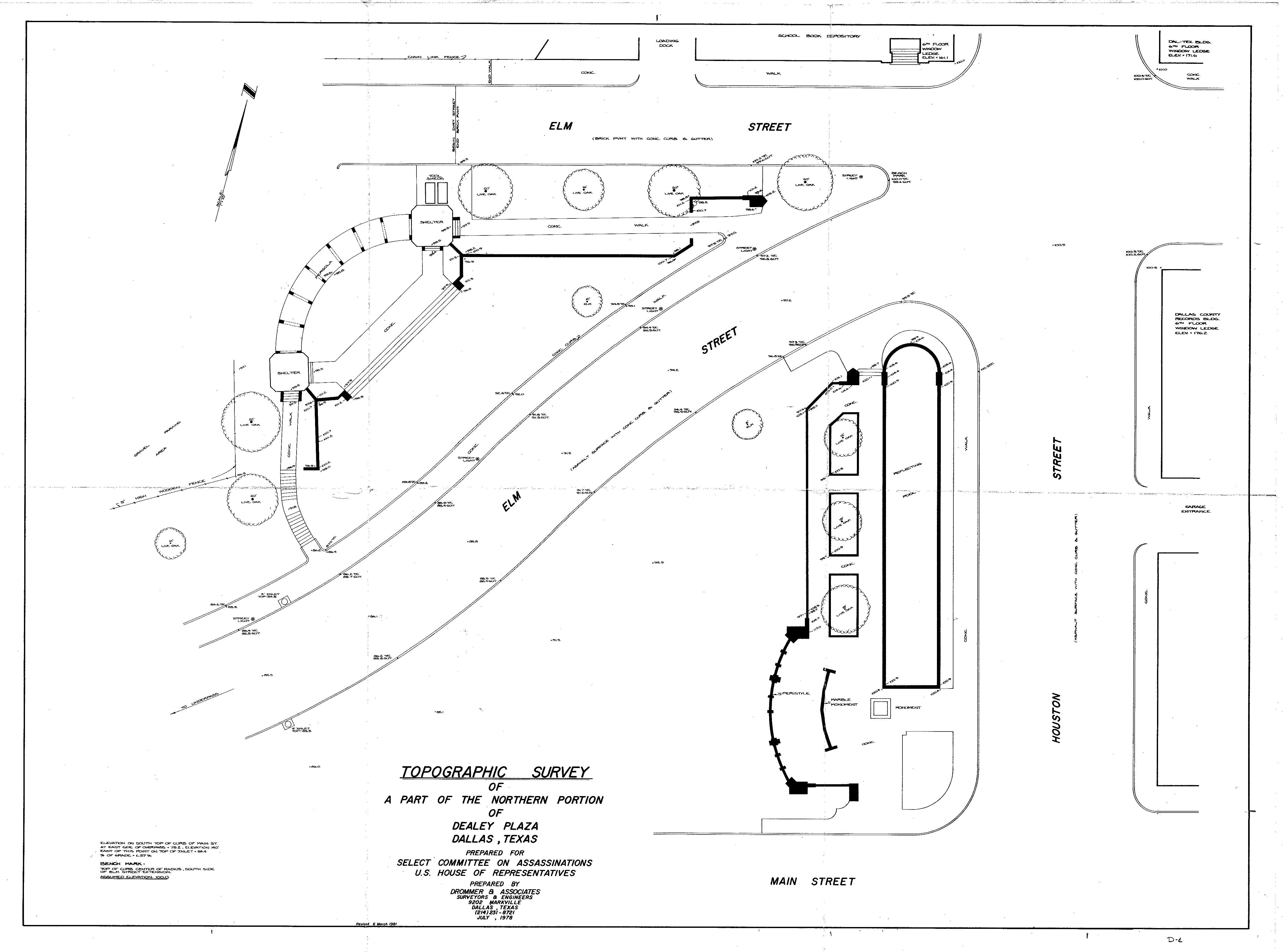
Figure 3: The Stemmons Freeway sign (front view) on November 22 and 24, 1963. - I did a careful analysis of the Topo Survey and determined it needed to be rotated 14.74° counterclockwise to make its compass rose point up. This rotation enables detailed work using the Costella panorama bearings. (Figures 4 and 5)
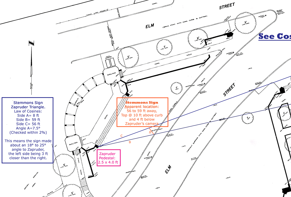
Figure 4: The topographical analysis of Dealey Plaza and the Apparent location of the Stemmons Freeway Sign (see Full size version) This survey has been cleaned up by me to remove a lot of the original scanning errors. True North up. 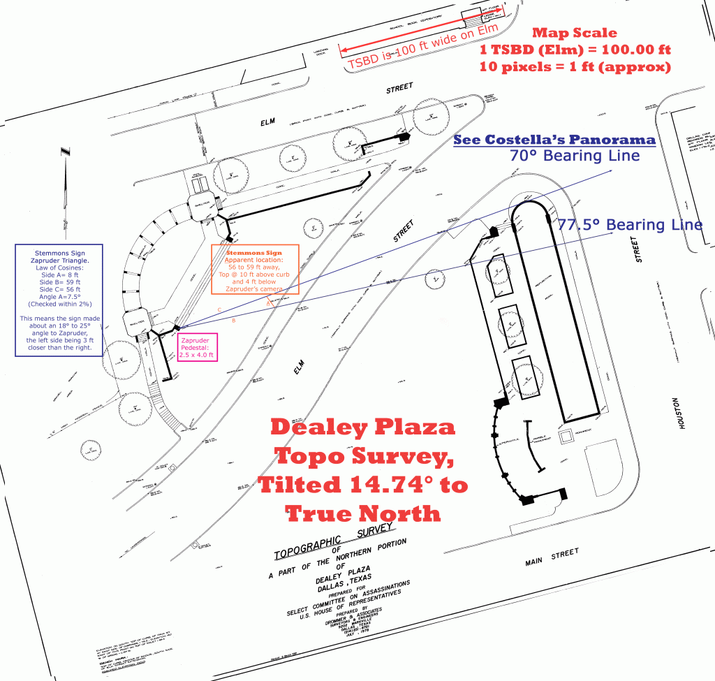
Figure 5: The full version of the sign calculations, tilted to True North and to scale. - My original Topo Survey was produced at nearly 10 pixels to 1 ft. in real life. This is convenient for measuring.
- I assume that Zapruder’s camera was 5 ft. above the pedestal where he stood.
- I have no immediate source for this, but I determined that the Stemmons Sign is supposedly a virtually flat plywood sign having nominal dimensions of 8 ft. wide by 4 ft. tall. This is an important assumption.

Research: Analysis and Calculations
My analysis is pretty straightforward. (Figures 4 and 5) The goal is to locate the freeway sign to within a foot or two. A more detailed study might be able to reduce the uncertainty further, but the main problem is the movement of Zapruder and the variability of the panorama work by Costella. There is a little guesswork, too.
- Using that source data, I was quickly able to draw some bearing lines on the corrected Topo survey. I drew one at 70° and one at 77.5° corresponding to what I feel represents the left and right edge of the sign in Costella’s panorama. Hopefully, this is close enough for our purposes.
- Using trial and error, I tried to place an 8 ft. wide side sign near the sidewalk. I rotated and adjusted the sign until it fit approximately where it appears in the Zapruder Film.
- When I chose the location, I noted that it does not sit perpendicular to the adjacent street. Perhaps it is facing closer to the center of the street about 120 ft. away.
- This Apparent location completed a triangle on the survey which could be further scrutinized.
- To check my work, I applied the Law of Cosines to the estimated distances and the 7.5° angle that the sign subtends. The calculation that I initially did appeared to give a reasonably accurate solution to this triangle. (Figure 6)
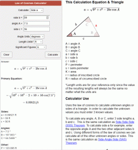
Figure 6: Law of Cosines to check the Zapruder Triangle - To further ensure that the location was reasonable, I applied a right triangle equation to the vertical dimension. Since Costella’s panorama shows a 4° depression from Zapruder to the top of the sign, this was instrumental in determining the height of the sign. A simple tangent function for the 4° depression gives 4 ft. of depression (at an average distance to Zapruder of 57 ft.). This calculation is this: 101.2 ft (Pedestal) + 5.0 ft (Zapruder) – 4 ft. (angular depression) – 92.6 ft (nearby sidewalk curb). This equals 9.6 ft for the height of the sign above the curb. My observation of the photo taken on the day of the assassination is that the sign is roughly 9 or 10 ft. high.
Conclusion
Therefore, my conclusion is that I have located the Stemmons sign to a reasonable amount of accuracy. Assuming that all of my assumptions and source data is correct, I would estimate that I have located the sign to within 2 ft. of its location. If there were some more serious errors in my assumptions or source data, I would put the sign within 4 ft.
I have read that Zapruder filmed nearly perpendicular to the sign. I find that a gross exaggeration. My analysis is that it is skewed 18° to 25° from being perpendicular to him, depending on where you measure the sign.
Future research will be able to determine the angular field of view for Zapruder’s camera with and without the sprockets and ensure that this is close to the field of view associated with a Bell & Howell Zoomatic 414PD 8mm camera using full telephoto. I’d like to make sure that this is the same in multiple frames of the film.
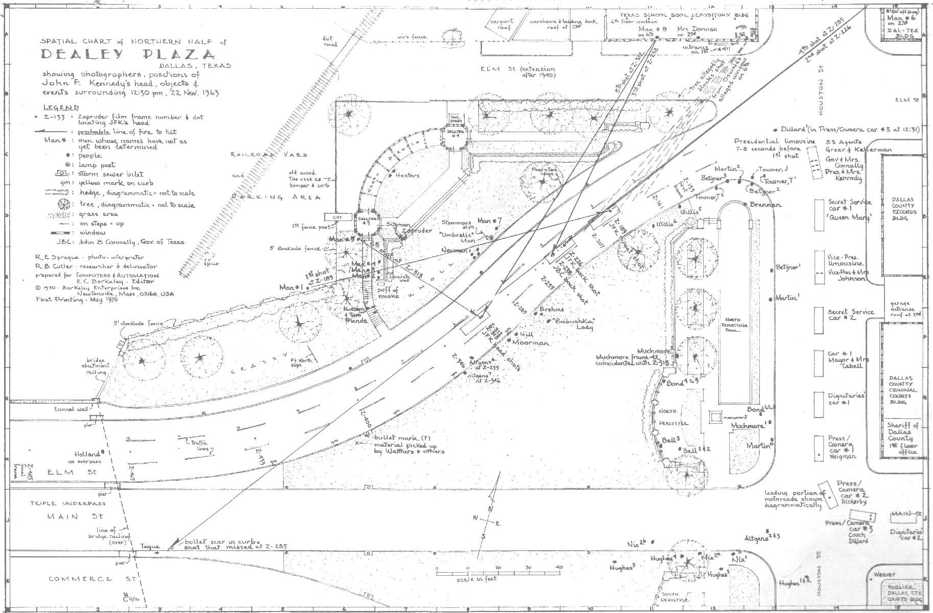
While conducting this analysis, I came across an erroneous survey of Dealey Plaza in which the “scale in feet” is way, way off. (You need to make the 40 ft scale read about 80 or use the TSBD for your scale if you need to work with this “other” survey.) Incidentally, this “Spatial Chart of Northern Half of Dealey Plaza” shows the Stemmons sign, and it is very close to my calculated position. See Figure 7.
There is another type of calculation which could be conducted using other photos of the Stemmons sign. In fact, a good photogrammetrist could take an overhead photo of Dealey Plaza and determine the location of the sign. If so, then Zapruder’s alleged position in any particular frame could be determined. Here is one such photo from November 25, 1963, presented in Figure 8.
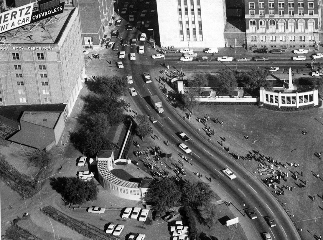
In my next analysis, I will take this aerial view and compare it to the Zapruder film and my calculated position. There seems to be a discrepancy in the two locations. Was Zapruder not filming there? Is Costella’s panorama wrong? Or is there some other error? Also, what about the Bronson slide, Bond’s photo, Art Rickerby’s photo in the street, and Willis #5? We’ll explore this in Part 2. [Spoiler alert (Don’t read this): I move my sign about 4 feet or so and my assumption that the sign is 1 ft. from the sidewalk is upended.]
I hope I can locate your Part 2 expose to study your updated and upended conclusions.
Your assumption that the sign is 1 ft. from the sidewalk is indeed inaccurate. I hope to see how that fact plays out.
That “other” survey is Richard E. Sprague’s famous and very accurate photographic interpretation survey. Right down to the irregular dashed painted lines on the road.
The “erroneous” scale you are referring to is itself trying to tell you that the border markers on the edge of the drawing are each 40 feet. It is not to be scaled directly. It is just a legend for the border markers.
If you look at Willis Photo #5 you will see that Umbrella Man was actually standing at the rear side of the Stemmons sign and 10 feet downhill. He is falsely placed alongside the Stemmons sign in Zapruder and on the front to “prove” Umbrella Man never signalled for more shots from the grassy knoll after he saw JFK’s head wasn’t sufficiently blasted yet.
Look at Zapruder’s lens in Willis photo #5. You can draw a straight line from his lens UNDER the Stemmons sign to JFK’s head and the limousine lower down (from Zapruder’s position of reference). In other words, Zapruder filmed JFK as he was passing UNDER the sign and getting shot in the right shoulder at about Z206 and the throat about Z220. That’s 0.77 seconds, which is not time enough to work the bolt on a rifle much less get off two shots. Not to mention the Z206 shoulder shot was from the rear and the Z220 shot into the throat was from the front. Not only was JFK fully visible to Zapruder’s camera, but look at the size of the sign for real in Willis, and notice in Zapruder the sign has been faked to be about 3 times its actual size. It not only was too high to cover up JFK in real life, it was left to right big enough to cover up only a part of the limousine, not the whole length of the limousine as purported in Zapruder 204.
The cut and paste job faking the sign was botched again in Z220, upper right corner. The other hoaxed frames have it as a nice rounded corner. But in Z220 somebody got in a hurry and suddenly put a flat spot on the corner that was rounded in Z219 and Z221.
We know JFK was hit in the shoulder first, because Kellerman (WCR 2:73) heard him exclaim, “My God, I am hit!” so his vocal cords were still intact. After he was hit in the throat he had a quizzical expression on his face (which Bill Newman also saw) and as Jackie leaned his way to see what was wrong he could only make a pained gurgling noise. At Z250 he was hit near his external occipital protuberance and the bullet stopped inside his head between the vomer bone and the right eye orbit. That is when he went unconscious, which is why you see his hands and arms start to drop at Z251, Z252, Z253……etc. This entrance hole was seen inside Trauma Room #1 by Parkland Dr. Robert Grossman, and part of the hole was later identified on the edge of the Harper Fragment photo by Dr. David Mantik, with a smudge of what has to be lead from the bullet.